Applied Satellite Navigation Using GPS, GALILEO, and Augmentation Systems

Chapter 8: Layer Issues

8.1 Introduction

The previous chapters showed the complex architecture, features, and services of the first, second, and intermediate generation of satellite navigation systems. The most fascinating feature of GNSS is their potential to cover a wide range of applications.

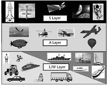
Both current and future applications of GNSS can be framed in a height-dependent model, where users are located in three main layers:

  1. Land/water (L/W) layer (Earth surface, oceans/seas/lakes/rivers);

  2. Air (A) layer (atmospheric region);

  3. Space (S) layer (above atmospheric region to deep space).

Each of the three layers hosts systems for various applications (e.g., road/rail transportation, navigation, aviation, surveying, leisure) that are or can become users of the GNSS services to improve performance/effectiveness/cost of the systems. A view of the layer model is exemplified in Figure 8.1, where some categories of users are pointed for each layer.


Figure 8.1: The layer model for GNSS users and applications.

The following sections present emerging and potential applications of GNSS grouped and described layer by layer.

UNLIMITED FREE
ACCESS
TO THE WORLD'S BEST IDEAS

SUBMIT
Already a GlobalSpec user? Log in.

This is embarrasing...

An error occurred while processing the form. Please try again in a few minutes.

Customize Your GlobalSpec Experience

Category: Boats, Ships, and Off Shore Vessels
Finish!
Privacy Policy

This is embarrasing...

An error occurred while processing the form. Please try again in a few minutes.