Digital Terrain Modeling: Acquisition, Manipulation, and Applications

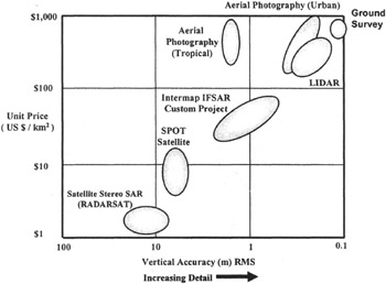
There is no question that current methods for generating DTM data meet the accuracy and resolution requirements for all the applications described in Chapter 1. However, the question has always been about how to produce low-cost, high-accuracy, high-resolution DTMs. The cost for generating DTMs using conventional approaches can become significant for increased resolution, accuracy, and especially number of elevation postings. Costs associated with various methods of generating DTMs are directly reflective of the labor-intensive and time-consuming processes currently used. Figure 2.29 shows a comparison of the cost (in U.S. dollars) of producing 1 km 2 against the accuracy of the different techniques presented in this chapter (for the sake of completeness, other techniques such as satellite imagery are also included in the figure). Other factors that decide on the choice of the technique to use include the other data that will be needed with the DTM, such as images. This might dictate the choice of the technique.