9.4.3 Earth Models
Inertial navigation and satellite navigation require models for the shape, gravity,
and rotation of the earth.
9.4.3.1 Navigation Coordinates Descriptions of the major coordinates used
in inertial navigation and GNSS/INS integration are described in Appendix C
(on the CD). These include coordinate systems used for representing the trajectories
of GNSS satellites and user vehicles in the near-earth environment and for
representing the attitudes of host vehicles relative to locally level coordinates,
including the following:
- Inertial coordinates:
(a) Earth-centered inertial (ECI), with origin at the center of mass of the
earth and principal axes in the directions of the vernal equinox (defined
in Section C.2.1) and the rotation axis of the earth.
(b) Satellite orbital coordinates, as illustrated in Fig. C.4 and used in GPS
ephemerides. - Earth-fixed coordinates:
(a) Earth-centered, earth-fixed (ECEF), with origin at the center of mass
of the earth and principal axes in the directions of the prime meridian
(defined in Section C.3.5) at the equator and the rotation axis of the
earth.
(b) Geodetic coordinates, based on an ellipsoid model for the shape of
the earth. Longitude in geodetic coordinates is the same as in ECEF
coordinates, and geodetic latitude as defined as the angle between the
equatorial plane and the normal to the reference ellipsoid surface.
Geodetic latitude can differ from geocentric latitude by as much as
12 arc minutes, equivalent to about 20 km of northing distance.
(c) Local tangent plane (LTP) coordinates, also called "locally level coordinates," essentially representing the earth as being locally flat. These
coordinates are particularly useful from a human factors standpoint for
representing the attitude of the host vehicle and for representing local
directions. They include
i. East-north-up (ENU), shown in Fig. C.7
ii. North-east-down (NED), which can be simpler to relate to vehicle
coordinates and
iii. Alpha wander, rotated from ENU coordinates through an angle a about the local vertical (see Fig. C.8)
- Vehicle-fixed coordinates:
(a) Roll-pitch-yaw (RPY) (axes shown in Fig. C.9).
Transformations between these different coordinate systems are important for
representing vehicle attitudes, for resolving inertial sensor outputs into inertial
navigation coordinates, and for GNSS/INS integration. Methods used for representing
and implementing coordinate transformations are also presented in
Appendix C, Section C.4.
9.4.3.2 Earth Rotation Our earth is the mother of all clocks. It has given us
the time units of days, hours, minutes, and seconds we use to manage our lives.
Not until the discovery of atomic clocks based on hyperfine transitions were we
able to observe the imperfections in our earth clock. Despite these, we continue
to use earth rotation as our primary time reference, adding or subtracting leap
seconds to atomic clocks to keep them synchronized to the rotation of the earth.
These time variations are significant for GNSS navigation, but not for inertial
navigation.
WGS84 Earthrate Model The value of earthrate in the World Geodetic System
1984 (WGS84) earth model used by GPS is 7, 292, 115, 167 10-14 radians per
second, or about 15.04109°/h. This is its sidereal rotation rate with respect to
distant stars. Its mean rotation rate with respect to the nearest star (our sun), as
viewed from the rotating earth, is 15°/h, averaged over one year.
9.4.3.3 GPS Gravity Models Accurate gravity modeling is important for maintaining
ephemerides for GPS satellites, and models developed for GPS have been
a boon to inertial navigation as well. However, spatial resolution of the earth gravitational
field required for GPS operation may be a bit coarse compared to that for
precision inertial navigation, because the GPS satellites are not near the surface
and the mass concentration anomalies that create surface gravity anomalies. GPS
orbits have very little sensitivity to surface-level undulations of the gravitational
field on the order of 100 km or less, but these can be important for high-precision
inertial systems.
9.4.3.4 INS Gravity Models Because an INS operates in a world with gravitational
accelerations it is unable to sense and unable to ignore, it must use a
reasonably faithful model of gravity.
Gravity models for the earth include centrifugal acceleration due to rotation of
the earth as well as true gravitational accelerations due to the mass distribution
of the earth, but they do not generally include oscillatory effects such as tidal
variations.
Gravitational Potential Gravitational potential is defined to be zero at a point
infinitely distant from all massive bodies and to decrease toward massive bodies
such as the earth. That is, a point at infinity is the reference point for gravitational
potential.
In effect, the gravitational potential at a point in or near the earth is defined
by the potential energy lost by a unit of mass falling to that point from infinite
altitude. In falling from infinity, potential energy is converted to kinetic energy,
mν2escape/2, where νescape is the escape velocity. Escape velocity at the surface of
the earth is about 11 km/s.
Gravitational Acceleration Gravitational acceleration is the negative gradient of
gravitational potential. Potential is a scalar function, and its gradient is a vector.
Because gravitational potential increases with altitude, its gradient points upward
and the negative gradient points downward.
Equipotential Surfaces An equipotential surface is a surface of constant gravitational
potential. If the ocean and atmosphere were not moving, then the surface of
the ocean at static equilibrium would be an equipotential surface. Mean sea level is a theoretical equipotential surface obtained by time averaging the dynamic
effects.
Ellipsoid Models for Earth Geodesy is the process of determining the shape of
the earth, often using ellipsoids as approximations of an equipotential surface
(e.g., mean sea level), as illustrated in Fig. 9.17. The most common ones are
ellipsoids of revolution, but there are many reference ellipsoids based on different
survey data. Some are global approximations and some are local approximations.
The global approximations deviate from a spherical surface by about ±10 km,
and locations on the earth referenced to different ellipsoidal approximations can
differ from one another by 102 - 103 m.
Geodetic latitude on a reference ellipsoid is measured in terms of the angle
between the equator and the normal to the ellipsoid surface, as illustrated in
Fig. 9.17.
Orthometric height is measured along the (curved) plumbline.
WGS84 Ellipsoid The World Geodetic System (WGS) is an international standard
for navigation coordinates. WGS84 is a reference earth model released in
1984. It approximates mean sea level by an ellipsoid of revolution with its rotation
axis coincident with the rotation axis of the earth, its center at the center of
mass of the earth, and its prime meridian through Greenwich. Its semimajor axis
(equatorial radius) is defined to be 6,378,137 m, and its semiminor axis (polar
radius) is defined to be 6,356,752.3142 m.
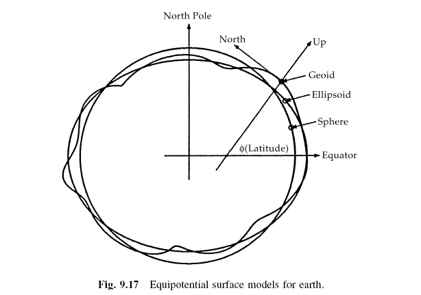
Geoid Models Geoids are approximations of mean sea-level orthometric height
with respect to a reference ellipsoid. Geoids are defined by additional higher
order shapes, such as spherical harmonics of height deviations from an ellipsoid,
as illustrated in Fig. 9.17. There are many geoid models based on different data,
but the more recent, most accurate models depend heavily on GPS data. Geoid
heights deviate from reference ellipsoids by tens of meters, typically.
The WGS84 geoid heights vary about ±100 m from the reference ellipsoid.
As a rule, oceans tend to have lower geoid heights and continents tend to have
higher geoid heights. Coarse 20-m contour intervals are plotted versus longitude
and latitude in Fig. 9.18, with geoid regions above the ellipsoid shaded gray.
9.4.3.5 Longitude and Latitude Rates The second integral of acceleration in
locally level coordinates should result in the estimated vehicle position. This
integral is somewhat less than straightforward when longitude and latitude are
the preferred horizontal location variables.
The rate of change of vehicle altitude equals its vertical velocity, which is
the first integral of net (i.e., including gravity) vertical acceleration. The rates of
change of vehicle longitude and latitude depend on the horizontal components of
vehicle velocity, but in a less direct manner. The relationship between longitude
and latitude rates and east and north velocities is further complicated by the
oblate shape of the earth.
The rates at which these angular coordinates change as the vehicle moves
tangent to the surface will depend on the radius of curvature of the reference

surface model, which is an ellipsoid of revolution for the WGS84 model. Radius
of curvature can depend on the direction of travel, and for an ellipsoidal model
there is one radius of curvature for north-south motion and another radius of
curvature for east-west motion.
Meridional Radius of Curvature The radius of curvature for north-south motion
is called the "meridional" radius of curvature, because north-south travel is along
a meridian (i.e., line of constant longitude). For an ellipsoid of revolution (the
WGS84 model), all meridians have the same shape, which is that of the ellipse
that was rotated to produce the ellipsoidal surface model. The tangent circle
with the same radius of curvature as the ellipse is called the "osculating" circle (osculating means "kissing"). As illustrated in Fig. 9.19 for an oblate earth
model, the radius of the meridional osculating circle is smallest where the geocentric
radius is largest (at the equator), and the radius of the osculating circle
is largest where the geocentric radius is smallest (at the poles). The osculating
circle lies inside or on the ellipsoid at the equator and outside or on the
ellipsoid at the poles and passes through the ellipsoid surface for latitudes in
between.

The formula for meridional radius of curvature as a function of geodetic
latitude (φgeodetic) is

where a is the semimajor axis of the ellipse, b is the semiminor axis, and e2 =
(a2 -b2)/a2 is the eccentricity squared.
Geodetic Latitude Rate The rate of change of geodetic latitude as a function of
north velocity is then
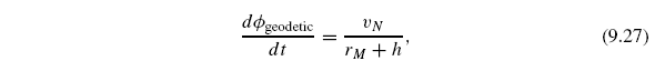
and geodetic latitude can be maintained as the integral
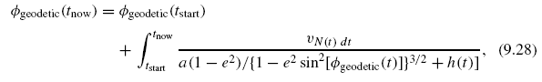
where h(t) is height above (+) or below (-) the ellipsoid surface and φgeodetic(t)
will be in radians if νN(t) is in meters per second and rM(t) and h(t) are in
meters.
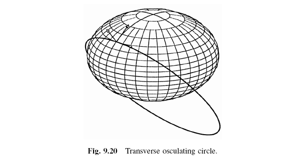
Transverse Radius of Curvature The radius of curvature of the reference ellipsoid
surface in the east-west direction (i.e., orthogonal to the direction in which
the meridional radius of curvature is measured) is called the transverse radius of
curvature. It is the radius of the osculating circle in the local east-up plane, as
illustrated in Fig. 9.20, where the arrows at the point of tangency of the transverse
osculating circle are in the local ENU coordinate directions. As this figure
illustrates, on an oblate earth, the plane of a transverse osculating circle does not
pass through the center of the earth, except when the point of osculation is at
the equator. (All osculating circles at the poles are in meridional planes.) Also,
unlike meridional osculating circles, transverse osculating circles generally lie
outside the ellipsoidal surface, except at the point of tangency and at the equator,
where the transverse osculating circle is the equator.
The formula for the transverse radius of curvature on an ellipsoid of
revolution is

where a is the semimajor axis of the generating ellipse and e is its eccentricity.
Longitude Rate The rate of change of longitude as a function of east velocity
is then

and longitude can be maintained by the integral
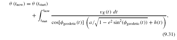
where h(t) is height above (+) or below (-) the ellipsoid surface and θ will
be in radians if νE(t) is in meters per second and rT (t) and h(t) are in meters.
Note that this formula has a singularity at the poles, where cos(φgeodetic) = 0, a
consequence of using latitude and longitude as location variables.
WGS84 Reference Surface Curvatures The apparent variations in meridional
radius of curvature in Fig. 9.19 are rather large because the ellipse used in generating
Fig. 9.19 has an eccentricity of about 0.75. The WGS84 ellipse has an
eccentricity of about 0.08, with geocentric, meridional, and transverse radius of
curvature as plotted in Fig. 9.21 versus geodetic latitude. For the WGS84 model:
- Mean geocentric radius is about 6371 km, from which it varies by -14.3
km (-0.22%) to +7.1 km (+0.11%).
- Mean meridional radius of curvature is about 6357 km, from which it varies
by -21.3 km (-0.33%) to 42.8 km (+0.67%).
- Mean transverse radius of curvature is about 6385 km, from which it varies
by -7.1 km (-0.11%) to +14.3 km (+0.22%).
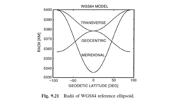
Because these vary by several parts per thousand, one must take radius of
curvature into account when integrating horizontal velocity increments to obtain
longitude and latitude.
© 2007