Well Logging and Formation Evaluation
Covering all aspects of well logging and formation evaluation, this comprehensive guide offers practical techniques that will be valuable to petrophysicists and engineers in their day-to-day jobs.
The trajectory of a deviated well may be described in terms of its inclination, depth, and azimuth. The inclination of a well at a given depth is the angle (in degrees) between the local vertical and the tangent to the wellbore axis at that depth (Figure 13.1.1). The convention is that 0 degrees is vertical and 90 degrees is horizontal. Parts of a degree are given in decimals, rather than minutes and seconds. Gravity varies with latitude, and its direction may be influenced by local features such as mineral deposits and mountains, as well as the Earth's rotation.
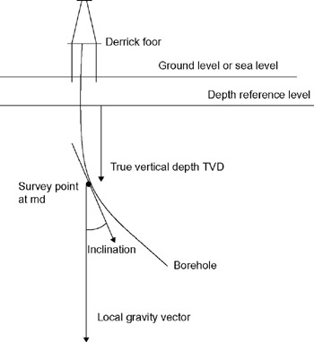
Depth in boreholes is measured either along the hole itself, in which case it is referred to as measured or alonghole depths, with reference to a fixed point, or as true vertical depth (TVD) with reference to a datum. Depth references that are commonly used are as follows:
Derrick floor. This is the elevated deck on which the rig crew work, typically 10m or so above ground level on a land rig and 20 30m on an offshore rig. Also sometimes referred to as a rotary table.
Kelly bushing. This is the top of the bushing, which rotates on the derrick floor (although kellys are rarely used on modern drilling rigs with topdrives) and is typically 1ft higher than the derrick floor.
Mean sea level. This is the elevation of the sea, averaging out the effect of tides or seasonal variations.