GPS has found its way into many applications, mainly as a result of its accuracy, global availability, and cost-effectiveness. Unfortunately, however, there exist some situations in which part of the GPS signal may be obstructed to the extent that the GPS receiver may not "see" enough satellites for positioning. Examples of those situations are positioning in urban canyons and deep open-pit mining. This signal-obstruction problem, however, was successfully overcome by integrating GPS with other positioning systems. In fact, reported results showed that the performance of the integrated system is better than either system alone. Augmenting GPS is not limited to sensor integration. As shown below, GPS can be augmented with computer-based tools, such as GIS, for efficient data collection and analysis.
9.1 GPS/GIS integration
A geographic information system (GIS) is a computer-based tool capable of acquiring, storing, manipulating, analyzing, and displaying spatially referenced data [1]. Spatially referenced data is data that is identified according to its geographic location (e.g., features such as streets, light poles, and fire hydrants are linked by geography).
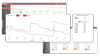
Spatial, or geographic, data can be obtained from a variety of sources such as existing maps, satellite imagery, and GPS. Once the information is collected, a GIS stores it as a collection of layers in the GIS database (see Figure 9.1). The GIS can then be used to analyze the information and decisions can be made efficiently. (For example, the decision to build a new road can be made by studying the effect of one feature, such as...
Copyright ARTECH HOUSE, INC. 2002 under license agreement with Books24x7