11.1 GLONASS satellite system
GLONASS is an all-weather global navigation satellite system developed by Russia. The GLONASS satellite system has much in common with the GPS system. The nominal constellation of the GLONASS system consists of 21 operational satellites plus three spares at a nominal altitude of 19,100 km. Eight GLONASS satellites are arranged in each of three orbital planes (see Figure 11.1). GLONASS orbits are approximately circular, with an orbital period of 11 hours and 15 minutes and an inclination of 64.8 [1, 2].
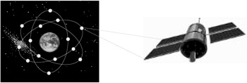 Figure 11.1: GLONASS system. (Satellite image courtesy of Magellan Corporation.)
 Similar to GPS, each GLONASS satellite transmits a signal that has a number of components: two L-band carriers, C/A-code on L1, P-code on both L1 and L2, and a navigation message. However, unlike GPS, each GLONASS satellite transmits its own carrier frequencies in the bands 1,602 1,615.5 MHz for L1 and 1,246 1,256.5 MHz for L2, depending on the channel number. These two bands are on their way to being shifted to 1,598.0625 1,604.25 MHz and 1,242.9375 1,247.75 MHz, respectively, to avoid interference with radio astronomers and operators of low-Earth-orbiting satellites. With this shift, each pair of GLONASS satellites will be assigned the same L1 and L2 frequencies. The satellite pairs, however, will be placed on the opposite sides of the Earth (antipodal), which means that a user cannot see them simultaneously. GLONASS codes are the same for all the satellites. As such, GLONASS receivers use the frequency channel rather than the code to distinguish the satellites. The chipping...


 TABLE OF CONTENTS