Engineering Surveying, Sixth Edition

With many worked examples and illustrations of tools and techniques, this important text gives readers a clear understanding of fundamentals such as vertical control, distance, angles and position.
 TABLE OF CONTENTS
 A control survey provides a framework of survey points, whose relative positions, in two or three dimensions, are known to specified degrees of accuracy. The areas covered by these points may extend over a whole country and form the basis for the national maps of that country. Alternatively the area may be relatively small, encompassing a construction site for which a large-scale plan is required. Although the areas covered in construction are usually quite small, the accuracy may be required to a very high order. The types of engineering project envisaged are the construction of long tunnels and/or bridges, deformation surveys for dams and reservoirs, three-dimensional tectonic ground movement for landslide prediction, to name just a few. Hence control networks provide a reference framework of points for:
Topographic mapping and large-scale plan production.
Dimensional control of construction work.
Deformation surveys for all manner of structures, both new and old.
The extension and densification of existing control networks.
The methods of establishing the vertical control have already been discussed in Chapter 3, so only two-dimensional horizontal control will be dealt with here. Elements of geodetic surveying will be dealt with in Chapter 8 and so we will concentrate upon plane surveying for engineering control here.
The methods used for control surveys are:
Traversing.
Intersection and resection.
Least squares estimation of survey networks.
Satellite position fixing (see Chapter 9).
A plane rectangular coordinates system is as defined in Figure 6.1.
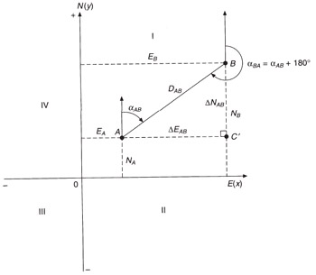
It...