Civil Engineering Survey Review, 3ed

Including many examples and problems with solutions, this detailed guide will help to prepare for the Special Civil Engineer (CE) Exam which is required for all civil engineer examinees.
Scale of a vertical photograph is the ratio of photo distance to ground distance. From Fig. 6-A, for similar triangles, the scale equation at point A is expressed as:
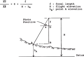
In general, the scale S at any point may be expressed as:

The C-Factor is the ratio of flight height above ground to the contour interval.

Photo scale can be determined from a map scale for the same area. It is calculated as follows:

A camera for aerial photography has 6 in focal length. At a flying height 10,000 ft above mean sea level, what is the photo scale on the ground 2,000 ft above mean sea level?
Solution:
From Eq. (6-1)

A plotter is used for mapping the C-factor is 1200, at what height should the plane fly above mean terrain in order to plot 5 ft interval contour?
Solution:
From Eq. (6-2)

On a vertical photograph, the length of an airport runway is 3.6 in. On a map of scale 1:12,000, it measures 4.5 in. What is the photo scale at the runway elevation?
Solution:
From Eq. (6-3)

The scale of the photograph is 1:12,000; The camera has a 6-in focal length with 9 9 in format. Forward overlap is 60%, side lap is 30%. The flight plan is to cover 5 miles wide and 20 miles long.
REQUIRED
What is the flying height above mean terrain?
What is the distance between exposures?
How many photographs are required per flight...

 TABLE OF CONTENTS