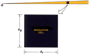
Introduction to Airborne Radar, Second Edition


An increasingly important airborne radar application is making radar maps of sufficiently fine resolution that topographic features and objects on the ground can be recognized.
In this chapter, we will learn how ground map resolution is defined and see what the optimum resolution is for various uses; then, review the approaches taken to providing it.
The quality of the ground maps produced by a radar is gauged primarily by the ability of the radar to resolve closely spaced features of the terrain. This ability is generally defined in terms of resolution distance and cell size.
Resolution distance is the minimum distance by which two points on the ground may be separated and still be discerned individually by the radar. The separation is usually expressed in terms of a range component, d r, and an azimuth or cross range component, d a the component at right angles to the line of sight from the radar.
A resolution cell, or "pixel" (for picture element), [1] is a rectangle whose sides are d r and d a (Fig. 1). Because features of the terrain may be oriented in any direction, ideally d r and d a are equal, making the cell a square.