Radar Cross Section Measurements
Presenting and explaining the rules of good measurement practice, this valuable reference explains how RCS is typically measured on test ranges, and how testing may be tailored to meet specific requirements.
The measurement of range (or a time delay from which range can be determined) is only one part of a more complete set of information available from the tracking radar. That set is often called metric data, which is a history of the target position in space. Typically described in a Cartesian coordinate system, it demands three components, of which range is only one: the other two are the azimuth and elevation angles to the target as seen from the radar. We may relate the two by any of several means, one of which is suggested in fig. 11.13.
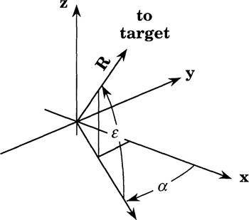
The Cartesian coordinates of the target as measured in this system are
where R is the slant range to the target and ? and ? are the azimuth and elevation angles of the target as seen from the tracker. These angles are typically extracted from azimuth and elevation shaft-angle encoders installed on the tracker radar pedestal. In the event the physical separation of the instrumentation radar pedestals from the tracker pedestal cannot be ignored, the geometry of radar installation complex may be measured and the corresponding angles as seen from the instrumentation radar pedestal may be computed. We will ignore this refinement in the computed examples of metric data presented...