Mastering AutoCAD Civil 3D 2008

Full of advanced techniques and insider tips, this tutorial-based guide will help you understand concepts, create perfect designs, and manage every stage of the project.
 TABLE OF CONTENTS
 The foundation of any civil engineering project is the simple point. Most commonly, we think of points as identifying the location of existing features, such as trees and property corners; topography, such as ground shots; or stakeout information, such as road geometry points. However, points can be used for much more. This chapter will focus on both traditional point uses and introduce ideas to apply the dynamic power of point editing, labeling, and grouping to other applications. By the end of this chapter, you will be able to:
Import points from a text file using description key matching
Create a point group
Export points to LandXML and ASCII format
Create a point table
Civil 3D points are intelligent objects that represent x, y, and z locations in space. Each point has a unique number and, optionally, a unique name that can be used for additional identification and labeling.
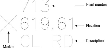
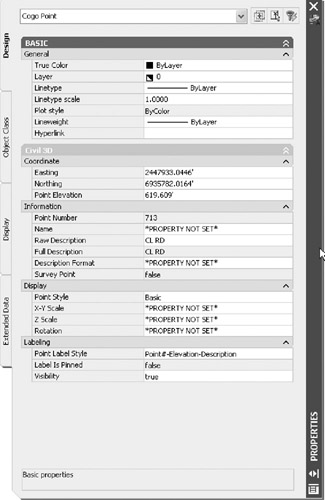
In previous releases of Civil 3D, points were not really individual objects. The point group was considered the object, and a point was considered a component of the point group. In Civil 3D 2008, the point (see Figure 4.1) behaves as an individual object that can be moved, rotated, and manipulated with far greater ease than in previous releases. Point properties can be viewed and changed in the AutoCAD Properties palette, as shown in Figure 4.2.