Understanding Synthetic Aperture Radar Images
By helping you to quickly assess which components of an SAR image should be measured, this book enables you to devote more time and energy to the real task of image interpretation and analysis.
Techniques for removing speckle from SAR images and deriving the RCS were described in Chapters 6 and 7. Information is then carried at the single-pixel level. However, this is not the only type of information contained in a SAR image. We illustrate this in Figure 8.1 with an example of airborne SAR imagery from the Tapajos region of the Amazon rain forest, obtained with the CCRS C-band system, as part of the SAREX program [1 3]. These 6-m resolution, 5-look data were obtained with illumination from the right at an incidence angle of about 60 degrees. A highway runs diagonally from top right to bottom left. The region to the left of this is comprised of primary forest; while that to the right is made up of a mixture of primary forest, secondary forest, and clearings with pasture and crops.
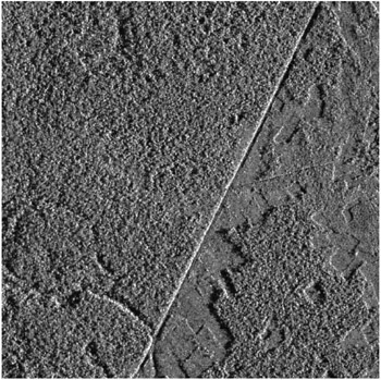
Suppose that the remote sensing task is to distinguish those regions that correspond to primary forest from secondary forest and clearings. It is apparent that the radar return in this image falls into two categories. One, corresponding to secondary forest and clearings, has no fluctuations above those expected for 5-look speckle. This is caused by the fact that vegetation is sufficiently dense and uniform so that the RCS is effectively constant. The other, corresponding to primary forest, has appreciable excess fluctuations caused by tall trees penetrating the canopy and resulting in bright tree crowns...